Chapter 2: Shaping of the Earth’s Surface
Verified step-by-step solutions for your class notes.
Q1
What are the sources of energy that are required to cause movements associated with the internal forces of the Earth?
- Core Heat Source: The movements driven by the Earth's internal forces are powered by intense heat originating from the planet's core.
- Convection Mechanism: This extreme heat warms the molten material within the mantle, creating massive, continuous convection currents where hot material rises and cooler material sinks. These strong thermal currents act as a subterranean engine that pushes and pulls the tectonic plates, causing the outer crust to shift.
Q2
Relate various physiographic divisions you have studied in the earlier grades with various endogenic forces responsible for their origin.
- Mountain Building: Internal or endogenic forces operating within the Earth—specifically plate movements like folding and faulting—are directly responsible for creating major macro-landforms such as mountains, plains, and valleys.
- Tectonic Collisions: For instance, when two massive continental landmasses move toward each other at a convergent boundary, the immense pressure buckles the crust. This specific endogenic force drives the formation of majestic fold mountain ranges, a prime example being the Himalaya.
Q3
Why and where do earthquakes occur frequently? Is it possible to predict earthquakes?
- Geographic Distribution: Earthquakes occur frequently along plate boundaries—the edges where tectonic plates meet and slide past, pull apart, or crash into one another. A vast majority of these seismic events take place around the Pacific Ocean in a highly active region famously known as the Ring of Fire.
- Predictability Limitations: While modern geologists study plate maps to pinpoint high-risk zones and help cities manage potential disasters, exactly predicting their timing remains incredibly difficult. Historically, scholars like Varāhamihira attempted to track environmental clues like animal behaviour, clouds, and wind changes to signal them, reflecting an early attempt to blend observation with cosmological reasoning.
Q4
"Plate movements are responsible for the distribution of earthquakes and volcanoes." Explain.
- Boundary Dynamics: Tectonic plates are in a state of slow, constant motion driven by mantle convection. The intense friction, pressure, and structural cracking that happen where these massive slabs of solid rock interact create the perfect conditions for geological instability.
- Seismic Realities: When plates pull apart at divergent boundaries, magma forces its way up to create new crust, and when plates collide at convergent boundaries, tectonic activity triggers severe volcanic eruptions and earthquakes. Because these violent releases of sub-crustal energy are concentrated right along the margins where plates grind together, most of the world's volcanoes and earthquakes align perfectly with plate borders.
Q5
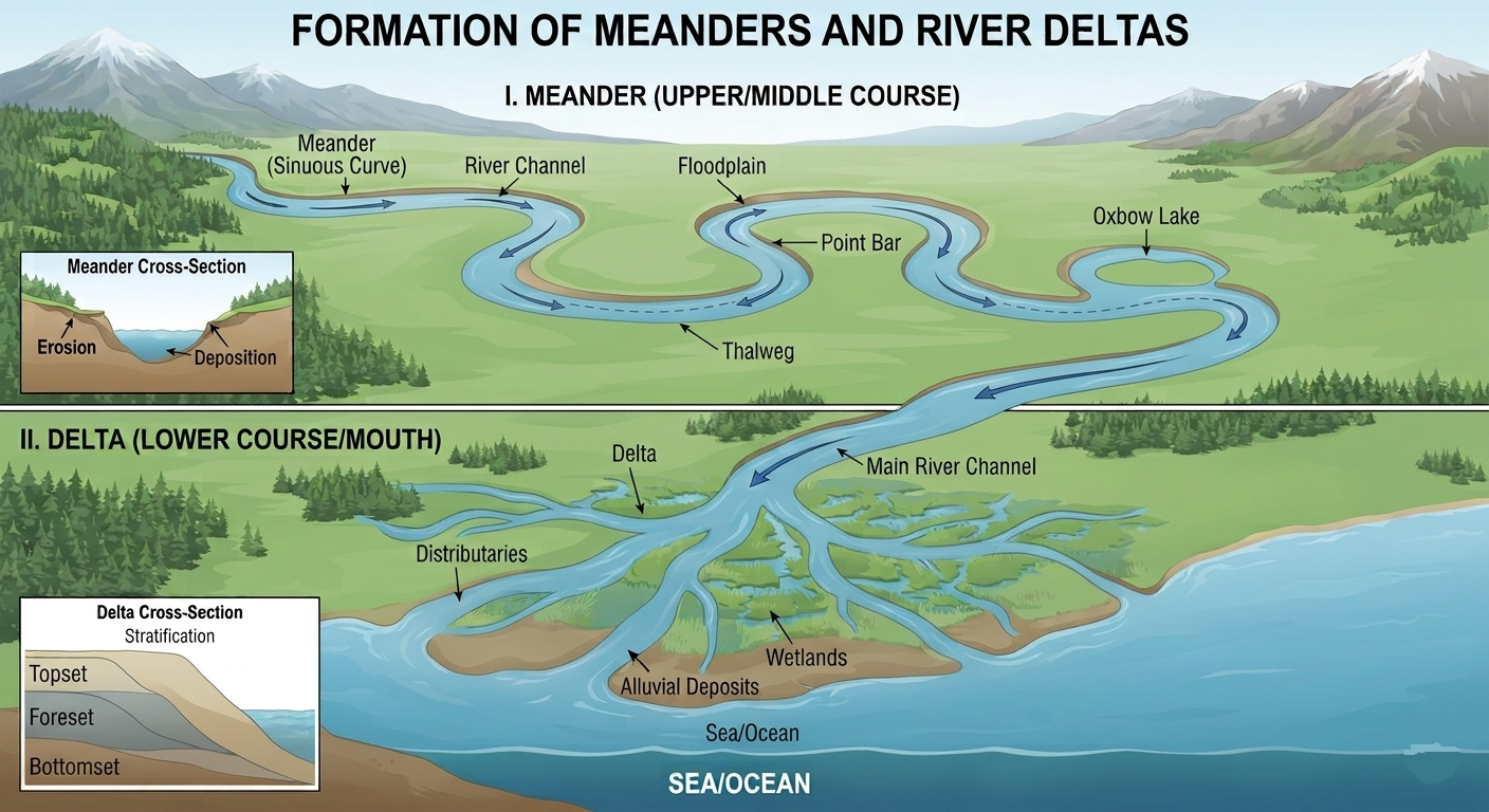
Draw and label a diagram of a meander and a delta.
- Meander and Delta Features: A meander is a winding curve or loop formed in the middle or lower course of a river due to lateral erosion on outer banks and sediment deposition on inner banks. A delta is a fan-shaped or triangular landform created at a river's mouth where it slows down, enters a sea or lake, and deposits its remaining load.
- Visual Presentation: The structural configurations, layout, and labeling criteria for both of these water-formed landscape modifications are illustrated below.
Q6
How are deforestation and erosion associated with each other? Explain.
- Loss of Soil Anchor: Deforestation severely accelerates surface erosion by removing the vital root networks that naturally anchor the soil together. Without this protective root system and vegetation cover, the raw land is left completely exposed and vulnerable.
- Environmental Domino Effect: Once the vegetation is stripped away, natural forces like heavy rainfall and strong winds can easily wear down and sweep the fertile topsoil away. This lack of root stability on hillsides and slopes noticeably increases the risk of sudden natural disasters like landslides.
Q7
Develop a plan to protect the land in your local area from erosion.
- Afforestation and Vegetative Cover: Plant native trees, shrubs, and grasses along exposed soil surfaces, roadsides, and riverbanks to establish root networks that bind soil particles and curb water runoff.
- Terracing and Bunding on Slopes: Implement step-terracing and earthen embankments along natural contour lines on elevated ground to slow down surface runoff velocity and enhance groundwater absorption.
- Proper Drainage Systems and Check Dams: Build structured runoff channels and check dams across gullies to minimize the gouging power of rainwater and trap dislodged topsoil.
Q8
Which disasters do you think you might experience in your region? Discuss a mitigation plan in your classroom.
- Regional Disaster Identification: Regions along river basins and coastal belts frequently experience flash floods and storm surges, hilly terrains are prone to landslides, and arid regions regularly encounter dust storms.
- Classroom Mitigation Strategy: Establish community early warning systems, organize regular evacuation drills, avoid unplanned construction along unstable slopes or flood lines, and construct robust protective structures such as embankments and check dams.
Q9
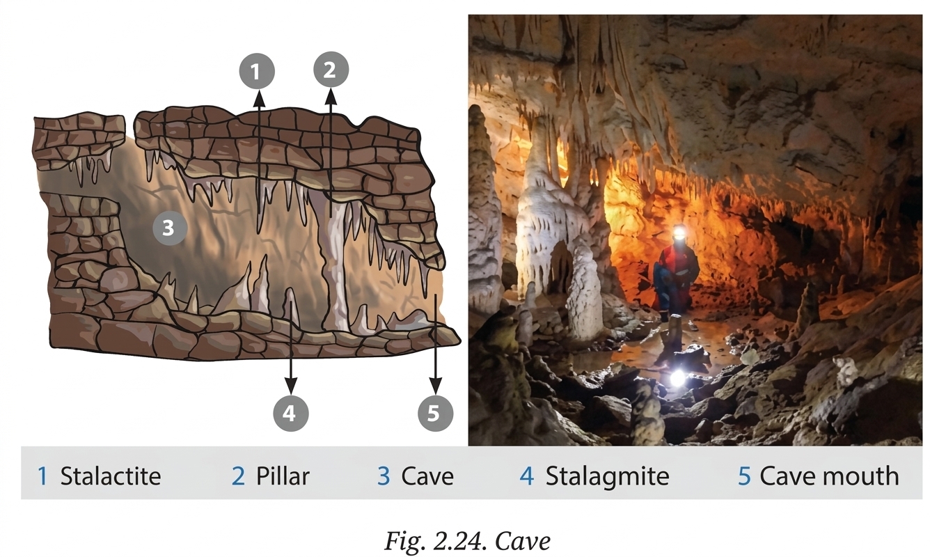
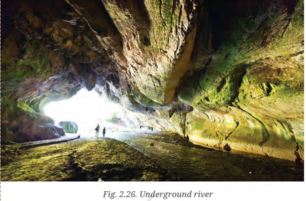
Prepare a model of landforms created by underground water.
- Core Landforms to Model: Illustrate a Karst limestone landscape displaying sinkholes/dolines on the surface crust, hollow cavern chambers underneath, stalactites hanging from the ceiling, stalagmites rising from the floor, joined limestone pillars, and subterranean rivers.
- Suggested Materials: Use clay, papier-mâché, or plaster of Paris mounted inside an open cardboard box to reveal both the surface collapse holes and the internal cavern formations.
Q10
What precautionary measures will you take if you are staying in an earthquake-prone region?
- Structural & Home Preparedness: Construct buildings following earthquake-resistant architectural codes, firmly bolt heavy furniture and appliances to walls, and maintain an emergency kit stocked with first-aid essentials, water, and flashlights.
- During and Immediate Response: Practice the "Drop, Cover, and Hold On" procedure under sturdy tables away from glass windows and power lines; if outdoors, move directly into open spaces away from tall buildings, bridges, and electric poles.
Q11
Prepare a map showing landform-associated disasters that happened in the current calendar year.
- Mapping Procedure: Acquire an outline map of India or the world and categorize recent disaster incidents using distinct color-coded markers or symbols (e.g., brown triangles for landslides, blue symbols for GLOFs/floods, red dots for earthquakes, and yellow bands for dust storms).
- Required Information: Collect verified disaster reports from current news sources detailing the location, date, affected landform type, and recorded impact.
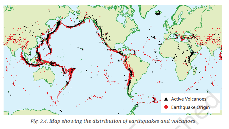
Fig. 2.4: Reference map showing distribution of earthquake origins and volcanic activity along tectonic boundaries.
Q12
Create a poster showing landforms that are considered to be sacred or important in your region, and add the folk stories associated with them.
- 1. Sacred Mountain Summits (Himalayan Fold Mountains - Mt. Kailash & Nanda Devi): Revered across Himalayan folklore as the celestial axis and the cosmic abode of Lord Shiva and Goddess Parvati. Local folklore tells that the snow-clad peaks stand as divine guardians safeguarding the northern plains from freezing winds. Indigenous communities perform circumambulations (Parikrama) and consider scaling these summits forbidden, a tradition that historically protected fragile high-altitude alpine ecology from human encroachment.
- 2. Holy River Confluence (Sangam at Prayagraj - Fluvial River Plains): In folklore and epic tradition, this is the sacred meeting point where the Ganga, Yamuna, and mythical subterranean Saraswati converge. According to the Samudra Manthan folk legend, celestial drops of the nectar of immortality (Amrita) spilled into the river here. The visibly contrasting shades—the deep emerald of the Yamuna and the silt-laden ochre of the Ganga—symbolize the harmony of natural elements, inspiring annual gatherings like the Magh and Kumbh Mela centered on river purification.
- 3. Sacred Limestone Caverns (Karst Cave Formations - Amarnath & Gupteshwar Caves): Formed deep within carbonate rock by the persistent action of underground water dissolving and redepositing calcium carbonate into stalactites and stalagmites. In regional folklore, Lord Shiva chose this secluded cave to narrate the secret of creation and immortality (Amar Katha) to Goddess Parvati, where ice stalagmites form natural sacred icons each year. These legends fostered deep respect for subterranean aquifers and sacred springs among local communities.
- 4. Community Conservation Value: Connecting sacred folklore with distinctive geological landforms is one of the world's oldest forms of community-led environmental stewardship, safeguarding mountains, riverbanks, and forests through cultural reverence.
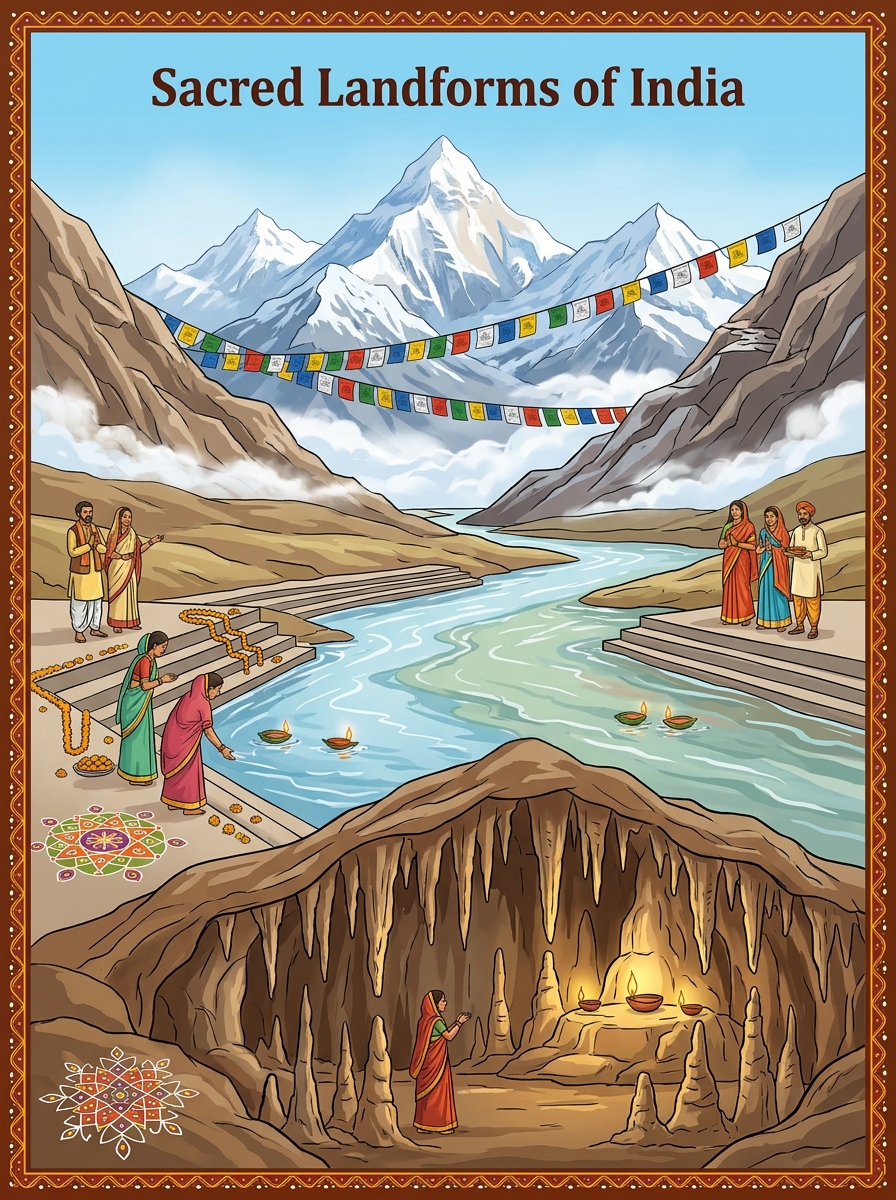
🎨 Student Exhibition Poster: Sacred Landforms of India & Associated Folk Traditions
Depicting sacred Himalayan snow peaks with prayer flags, the holy river confluence (Sangam) with prayer ghats and floating lamps, and illuminated karst cave formations.
Q13
Document a case of a disaster that hit your region in the past, highlighting its effects on various human activities.
- Disaster Case Profile (Chamoli Flash Flood, Uttarakhand):
• Event & Date: The Chamoli Disaster occurred on 7 February 2021 in the Garhwal Himalayas of Uttarakhand.
• Location & Affected River Valleys: Chamoli district, surging violently down the catchment basins of the Rishiganga, Dhauliganga, and Alaknanda rivers.
• Physical Trigger: A massive rock and ice mass detached from the steep slope of Ronti peak (near Nanda Devi), crashing down into the valley floor. The frictional heating rapidly melted glacial ice, transforming into a high-velocity, hyper-concentrated debris flow of ice, water, mud, and gigantic boulders. - Impact on Human Activities:
• 1. Damage to Transport & Infrastructure: The flash flood washed away five crucial bridges, including the vital border road bridge near Raini village connecting Joshimath to Malari along the Indo-Tibetan border. Severed roads cut off around 13 border villages, paralyzing vehicular movement and supply deliveries.
• 2. Paralyzed Energy & Power Grids: The debris torrent obliterated the 13.2 MW Rishiganga Hydroelectric Project and inflicted catastrophic structural destruction on NTPC's 520 MW Tapovan Vishnugad Hydropower Project, burying headrace tunnels in sludge and knocking out regional electricity supply.
• 3. Destruction of Agriculture & Soil Erosion: Violent flood surges stripped and eroded fertile river terrace soils, washing away standing winter crops and dumping tons of silt and rubble onto farm lands. Critical irrigation canals and riverside pastures were entirely destroyed.
• 4. Disruption of Human Settlements & Economy: More than 200 laborers, villagers, and personnel lost their lives or were declared missing. Riverbank dwellings and local market stalls were swept away, while pilgrimage tourism and trekking livelihoods suffered severe long-term setbacks.
• 5. Public Health & Drinking Water: Churning sediment heavily contaminated downstream drinking water supplies, forcing authorities to arrange emergency water shipments and portable filtration units for affected settlements.
Q14
Translate the given poster on landslide into your native language and display it in your home.
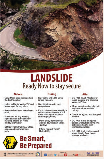
- Landslide Safety Poster Guide (Ready Now to Stay Secure):
Below is the structured safety poster adapted for home display and regional reference, organized across the three critical disaster preparedness phases:
LANDSLIDE SAFETY ACTION PLAN
Be Smart, Be Prepared | Ready Now to Stay Secure
1. Before (Preparedness)
- Plant Deep-Rooted Trees: Grow vegetation and native trees that hold topsoil together firmly on slopes.
- Monitor Weather Alerts: Listen to local radio, television, and official weather advisories for flash alerts.
- Maintain Clear Drainage: Keep surface drains and weep holes clean to prevent water buildup behind retaining walls.
- Watch for Warning Signs: Look out for ground subsidence, building tilting, cracks on rocks, or sudden muddying of streams.
- Avoid Slope Construction: Never build homes or structures near steep, unstable hillsides or natural drainage paths.
2. During (Immediate Action)
- Stay Calm & Avoid Panic: Remain composed and disregard unverified rumors or panic messages.
- Stay Together: Keep your family and companions together in a secure, pre-identified safe zone.
- Heed Warning Sounds: If you hear unusual noises like trees cracking or boulders tumbling, evacuate the slip path immediately.
- Move to High Ground: Evacuate rapidly away from downstream valleys and gullies to stable, elevated ground.
- Alert Authorities: Immediately inform the nearest Tehsil, police post, or District Disaster HQ.
3. After (Recovery & Safety)
- Avoid Loose Debris & Wires: Never touch or walk over unstable slope debris, fallen electrical poles, or dangling power wires.
- Maintain Safe Distance: Stay away from the landslide path and river channel, as secondary slips often follow.
- Rescue & First Aid: Check for injured or trapped persons; administer first aid and do not move severely injured victims unless in danger.
- Avoid Untreated Water: Do not drink contaminated water directly from silted rivers, springs, or wells; boil or filter first.
📞 National Disaster Helpline (NDMA): 011-1078
Official Portal: www.ndma.gov.in
- Home Display Instructions: Mount this safety card prominently on your household notice board, refrigerator, or near the main doorway alongside local emergency contacts for quick reference during heavy rains.
Q15
Divide the class into three groups. Each group will work on one project (water, wind, and glacier). The project should highlight the causes, impact on human life and the environment, and mitigation measures.
- Group 1 (Running Water & Waves): Examines river flooding, gully erosion, and coastal retreat; impacts include damaged arable land and lost property; mitigations include building embankments, check dams, and mangrove restoration.
- Group 2 (Wind Action): Focuses on deflation, expanding sand dunes, and dust storms in arid tracts; impacts include topsoil desertification and respiratory hazards; mitigations include shelterbelt planting, sand fence stabilization, and sustainable grazing.
- Group 3 (Glaciers & Ice): Covers avalanches and GLOFs driven by warming trends and moraine dam collapse; impacts include downstream flooding and infrastructure loss; mitigations include satellite lake monitoring, early warning sensors, and controlled siphon draining.